
Wildfires are a major concern for power line operators. Region, weather conditions, land cover, vegetation type, and other factors can affect the intensity of wildfires. Unfortunately, the effects of climate change in certain regions will only continue to enhance their severity. While wildfires continue to become more widespread, their impact on the electrical grid will continue to be catastrophic - resulting in widespread blackouts for consumers and loss of revenue for producers.
Having an accurate map of fire damage around power lines corridors is essential for restoration strategy development. This brings us to our question:
How can power line operators utilize new technologies like satellite data to recover from the impact of wildfires on their power lines?
Satellite-Based Post-Wildfire Analysis
LiveEO utilizes our direct APIs with major satellite providers and our advanced machine learning techniques, combined with a version of the Burned Area Index (BAI), to identify and quantify the extent of burn damage in power line corridors after wildfires for our customers.
Identifying Burned Areas
The utilization of remote sensing and vegetation indices has become a widespread tool for tracking risk areas, monitoring active fires, and helping with the recovery process. Remote sensing can monitor and capture wildfire changes in a landscape by measuring the reflected or emitted radiation from objects.
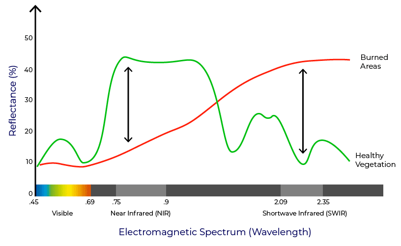
To distinguish between burned and unburned areas the "Red Edge" is essential. On the electromagnetic spectrum, right between where Chlorophyll is absorbed in the Red Visible range by vegetation, and the vegetation leaf’s structure scatters the NIR (Near Infrared) wavelengths, sits the Red Edge. The Red Edge is one of the best descriptors for Chlorophyll content and is the basis of the Normalized Difference Vegetation Index (NDVI).
Multitemporal Line Corridor Review
In partnership with Intel Geospatial, we completed a review of a utility's power line corridor post-wildfire to help them better understand the extent of the damage caused by the wildfire and to apply for Federal Emergency Management Agency (FEMA) assistance recovery funds. With a 10 m resolution, an Area of Interest (AOI) of 50 miles, and a corridor of 300ft, LiveEO’s Post-Wildfire Analysis was able to identify areas where fire directly contacted, or came close to contacting, power lines. This enabled our customers to efficiently organize their recovery program from their office before heading to the field.
Complete Overview of Fire Damage
From a high-level aerial view, the multitemporal satellite imagery shows the AOI between August and October 2020. The effects of the wildfire on the vegetation around the AOI are staggeringly visible. By understanding the exact location of the damages caused by wildfires, damage control strategies can begin in the office, and not in the field.


Comparison of September 4th imagery and post-fire September 27th imagery after the Post-Wildfire Analysis was conducted.
A comparison of the difference in the vegetation’s vitality before, and after the fire was also completed.

A review of just the corridor shows where the power lines were most directly impacted by the fires and had direct, or very close to direct, contact.

Get in Touch to Find Out More
Understanding how you can leverage remote sensing and satellite data to help plan post-disaster recovery is essential to a strong restoration strategy. Having an accurate map of fire damage around power lines can help provide a precise and safe evaluation of the burned area to determine the size and severity of the wildfire; while also allowing for the easy identification of compromised spans that require further inspection.
Our solution is capable of identifying and quantifying the extent of burn damages. LiveEO’s customers have used our Post-Wildfire Analysis to understand the wildfire’s size and severity better and apply for Federal Emergency Management Agency (FEMA) assistance recovery funds.
Contact us and let us help you recover from your wildfire today with a free initial consultation.
Learn more about wildfire mitigation here.
Get in touch!


